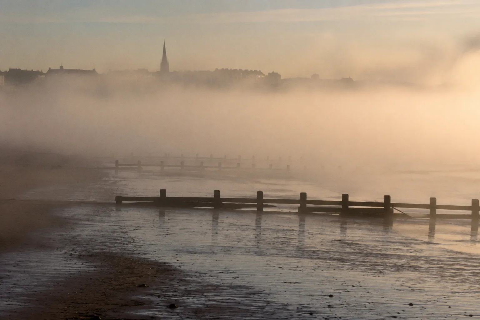
The horizon disappears, the beach loses its colour, and the sound of the road seems to soften. Visitors who walked down expecting a bright seaside afternoon meet instead the haar: a dense sea fog that has moved in from the Firth of Forth and settled along the coast.
For anyone trying to understand the edinburgh coastal haar phenomenon, this is the essential point: the fog is not simply a bad-weather version of an otherwise ordinary day. It is produced by the relationship between the cold sea, the warming land and the shape of the estuary. That is why Portobello, Joppa and the neighbouring shoreline can be wrapped in mist while much of the city remains clear.
For first-timers, the haar can feel almost theatrical, the way it eats the horizon and muffles the traffic around Portobello High Street. For anyone raised near the Firth of Forth, it is less a surprise than a familiar coastal interruption. It has its own timing, its own geography and its own vocabulary. Understanding why the haar settles where it does — and why it picks its moment — turns a baffling arrival into part of the texture of the shore.
The Mechanics of Advection: How the Haar Forms
The haar belongs to a family of fogs known in meteorology as advection fog. It forms when relatively warm, moisture-laden air moves across a colder surface and is cooled from below. Along the east coast of Scotland, that surface is the North Sea.
In late spring and summer, the land responds quickly to longer days and stronger sunshine. The sea changes temperature much more slowly. Even when Edinburgh has begun to feel properly warm, the water offshore can remain cold enough to chill the air passing over it. If a moist air mass moves across that colder water, the air cools to its dew point. Water vapour condenses into tiny suspended droplets, creating a low layer of fog.
That layer is the haar.
The process explains why the phenomenon feels different from ordinary inland mist. A ground fog often forms overnight in calm conditions, filling hollows and lifting as the sun rises. Haar is connected to moving air and to the sea surface. It can arrive as a coherent bank, pushed shoreward by an easterly or north-easterly flow, and it can remain dense even when the wider region is bright.
The haar is not weather that happens to reach the coast. It is weather made visible by the meeting of cold water and warm air.
The mechanics are straightforward once they are separated into stages:
1. Warm, humid air moves over colder seawater.
2. The lowest part of the air mass is cooled by contact with the surface.
3. Cooling brings the air to saturation.
4. Moisture condenses into microscopic droplets.
5. Wind carries the resulting fog towards the shore and, under the right conditions, inland.
The droplets are small enough to remain suspended rather than falling as rain. That gives the haar its particular texture: damp, opaque and close to the ground, but not necessarily wet in the way a rain shower is wet. It can bead on railings and clothing, soften distant lights and leave exposed skin feeling cold without producing a proper downpour.
The same broad physical process is known elsewhere as sea fret. The names vary across the east coast, but the underlying idea is similar: fog generated or intensified over cold seawater and then carried towards land.
At Portobello, the boundary can be remarkably abrupt. The promenade may be inside the haar while streets further inland remain much brighter. The change is not always gradual. A visitor can walk towards the beach under a clear sky and encounter a distinct band of colder, greyer air near the shore.
Seasonal Patterns: Why April to September Brings the Mist
The haar is most frequent from April through September, which is also the period when visitors are most likely to expect the coast to feel summery. The timing is not a contradiction. It is created by the seasonal difference between the land and the sea.
In spring, Edinburgh warms quickly during the day. Pavements, stone buildings, grass and dry ground all respond to the stronger sun. The North Sea remains much slower to warm. That leaves a pronounced temperature contrast between the air over land and the water offshore — precisely the contrast that makes advection fog more likely.
The pattern often continues into early and mid-summer. Warm air can move across the firth while the sea remains cold enough to cool it from below. A sea breeze may then bring the fog back towards the beach, even after a clear morning inland. Portobello beach sea fog is therefore not restricted to dawn. It can appear during the day when the wind and temperature structure are right.
The strongest likelihood is seasonal rather than fixed to a particular week. Haar is generally more common during the warmer part of the year, especially when:
- the land has warmed considerably during the day;
- the sea remains comparatively cold;
- the air contains enough moisture to condense;
- an easterly or north-easterly flow carries that air towards the coast;
- the atmosphere is stable enough for the fog layer to remain intact.
By late summer, the sea has had more time to warm and the temperature difference may become less favourable. The haar does not disappear, but it becomes more occasional. Autumn can still produce the right combination of a relatively warm, humid air mass and colder water, particularly when wind comes from the east. The calendar is a useful guide, not a switch.
That distinction matters in Portobello. It is reasonable to think of April to September as the main haar season, but not as a hard boundary. Fog can occur outside the peak period when the atmospheric setup allows it. A cold sea, moist air and an onshore wind matter more than the name of the month on the calendar.
The practical result is a coast with two kinds of summer day. On one, the beach is bright, the water is visible and the promenade feels connected to the city. On the other, the same stretch of sand seems to have been detached from Edinburgh and placed inside a private weather system. Both are normal for the Firth of Forth.
The Firth of Forth Funnel: Geography and Wind Dynamics
The haar does not spread evenly along a flat map. The shape of the Firth of Forth helps determine where it thickens, where it thins and how far inland it travels.
The firth is a broad estuary opening towards the North Sea and narrowing inland between the Fife and Lothian shores. When an easterly or north-easterly wind carries fog towards the coast, the estuary provides a natural corridor. Air and low cloud move into the mouth of the firth, while the two shores influence the direction and concentration of the flow.
On the Lothian side, the coastal sequence runs through areas including Musselburgh, Joppa, Portobello and Leith. On the opposite shore, the Fife coastline has its own towns, headlands and sheltered sections. The fog does not necessarily affect all of them in the same way. Small changes in wind direction, sea temperature, shoreline angle and local relief can make one section dense while another remains relatively clear.
Portobello is particularly exposed to weather arriving from the sea. Its beach faces broadly towards the east and north-east, and the long, open shoreline provides little shelter from an onshore flow. The sand and promenade form a low, continuous edge rather than a steep barrier. When fog is being pushed in from the firth, there is little topography to interrupt it.
Joppa sits within the same coastal system but does not always experience exactly the same conditions. The haar may arrive first at one section, break up over another or become more noticeable as it moves along the shore. That is one reason local observations can differ without either being wrong. A clear view from one part of the waterfront does not guarantee clear conditions a short distance away.
The sea breeze also matters. On a sunny day, land heats more quickly than water. Air rises over the warmer land, and cooler air from over the sea moves towards the shore. When a fog bank is already present offshore, that circulation can help draw it inland. It is one explanation for the familiar experience of a clear city morning followed by a grey beach afternoon.
The funnel effect is best understood as a tendency rather than a rigid channel. Wind does not follow the firth like water through a pipe. It is influenced by wider pressure systems, the angle of the coastline and local obstructions. Still, the estuary makes the east-facing shore vulnerable to fog moving in from the North Sea.
| Wind and weather pattern | Likely effect on the haar | What it may feel like at Portobello |
|---|---|---|
| Easterly or north-easterly flow | Carries moist air and fog towards the Lothian shore | Dense or persistent haar near the beach |
| Onshore sea breeze on a warm day | Can draw offshore fog inland | Fog arriving after a clearer morning |
| Light or calm wind | May leave fog offshore rather than advecting it inland | Clearer beach conditions despite mist over the water |
| Westerly flow | Pushes air from land towards the sea | A greater chance of the coast staying clear |
| Variable wind | Breaks up or shifts the fog bank | Rapid changes between mist, haze and sunshine |
This is also why the answer to why Edinburgh gets sea mist is not simply that Edinburgh is beside the sea. The city’s position on the southern edge of the firth, its open-facing beaches and the way the estuary receives easterly air all contribute to the local pattern.
Micro-Climates: The Ten-Degree Temperature Gap
The haar’s most distinctive feature for visitors is often not its appearance but its bite. It can turn a warm inland afternoon into a cold coastal one over a surprisingly short distance. The exact difference varies with the day, the wind and the thickness of the fog, but the change can be large enough to require another layer of clothing.
This is the small-scale geography of the coast: one city, several simultaneous weather conditions. The centre may be bright and warm while Portobello is grey. A street inland may feel comfortable in a shirt while the promenade calls for a jacket. The closer one gets to the water, the more pronounced the shift can become.
The difference is not only caused by shade. Haar is cold because the air has been cooled over the sea. That distinction is easy to feel. A shaded street can still be still and mild; a haar-covered beach often carries a damp, moving chill that works through clothing.
Local weather reading is therefore less about asking whether Edinburgh is sunny and more about asking which Edinburgh is sunny. The city forecast may describe conditions inland, while the coastal forecast gives a better indication of what will happen at the firth. A webcam, a view from higher ground or a quick look towards the shoreline can be just as useful as a general temperature reading.
On a haar day, the distance between the city and the beach is measured in weather, not miles.
The gradient can also run along the coast. Portobello, Joppa and Musselburgh may not sit inside identical air at the same moment. One section can have a visible horizon while another has lost the sea completely. Fog can thin at the edge, lift briefly and then return as the wind changes.
That instability is part of the phenomenon’s character. Haar is not always a solid wall that arrives once and stays put. It can move in pulses:
- a clear beach becomes hazy as the offshore bank advances;
- the fog thickens when the sea breeze strengthens;
- visibility improves when the wind shifts or the layer begins to lift;
- inland streets brighten while the waterfront remains cold;
- the haar retreats offshore, leaving damp rails and a muted shoreline behind.
The effect is especially noticeable for anyone travelling to the beach from the centre of Edinburgh. The route is short enough to make the contrast feel surprising. A forecast that seems perfectly suitable for a city walk may be misleading for a seaside afternoon. This is not a failure of the forecast so much as a reminder that coastal weather operates on a smaller scale than a single city-wide symbol can show.
Linguistic Roots: Tracing the History of the Haar
The word itself is older than the modern science used to explain the phenomenon. That is fitting for a weather pattern known through repeated experience long before it could be described in terms of dew points, air masses and sea-surface temperatures.
“Haar” is a regional word associated with cold sea fog along the east coast of Scotland and northern England. Further south, the related experience is often called sea fret. The vocabulary reflects the maritime connections of the North Sea, where weather terms travelled between communities through fishing, shipping and trade. Its precise linguistic history is discussed in different ways, but its modern meaning is clear to people who live along the coast: a low, cold fog arriving from the sea.
That local vocabulary does something a technical forecast cannot. It identifies the fog as a particular kind of weather rather than treating it as a generic reduction in visibility. A haar morning has a recognisable feel: the cold surface of the promenade, moisture on windows, a beach hidden behind grey air and a sudden need to change plans.
The word also preserves a practical relationship with the coast. People who know the term do not necessarily regard the haar as an exceptional event. It is part of the range of conditions that Portobello can produce, alongside bright summer evenings, wind off the water and long periods when the firth is perfectly visible.
Language follows repeated experience. A coastline that receives the same kind of fog often enough eventually gives it a name. In that sense, the word haar is a record of local observation. The science explains how the fog forms; the word records the fact that generations of people have had to live, work and travel through it.
Living With the Haar: A Practical Note for Visitors
For anyone planning a beach visit from central Edinburgh, the haar is worth reading as a coastal condition rather than treating it as a simple yes-or-no weather forecast. A few adjustments can make the difference between a comfortable day beside the water and an unexpectedly cold walk.
- Look at the coastal forecast as well as the city forecast. A general Edinburgh forecast may describe conditions inland. A forecast for the Forth estuary or the nearby coast is more useful when the question is whether fog will reach Portobello.
- Check the wind direction. An easterly or north-easterly flow, especially alongside a warm day on land, creates a more plausible haar setup than a steady wind from inland.
- Bring an extra layer. Even when the city feels warm, the beach can be distinctly colder. A waterproof outer layer is useful too, since dense fog can leave clothing and bags damp.
- Allow for rapid changes. The haar may sit offshore, move in during the afternoon or retreat for a while before returning. Conditions at the start of a walk do not guarantee the same conditions at the end.
- Use higher ground for a wider view. From an elevated point inland, it may be possible to see whether the fog is parked over the water or has already reached the beach. The position of the haar bank can tell you more than the colour of the sky directly overhead.
- Treat the fog as part of the coastline. A haar day is not automatically a ruined beach day. The light is softer, the crowds may be thinner and the shore takes on a different atmosphere. The sensible response is to adjust the plan rather than expect the beach to behave like the city centre.
The haar will continue to settle along Portobello whenever the conditions allow: cold water, moist air and a wind capable of carrying the fog towards shore. Its most frequent season runs from spring into summer, but the phenomenon is not bound to a precise local calendar. It can appear outside the peak period when the temperature contrast and wind direction line up.
That is why the haar remains one of the defining details of the Firth of Forth coast. It gives Portobello a weather identity separate from the rest of Edinburgh, and it makes the short journey from the city to the beach feel meteorologically much longer. Stand on the promenade inside the fog and the coast seems to have drawn its own boundary — not a permanent one, but a real one, shaped by the sea and rewritten each time the air moves inland.